


Product
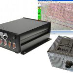
AeroDiDOS
PRICE
500$
AeroDiDOS
Is a Deep integrated Direct Orientation System for direct geo referencing of aerial images scanner data.
Direct georeferencing for your camera or scanner
AeroDiDOS-2 is the second generation of a deep integration of GPS and INS Technology for aerial surveying applications. Synchronized Position Attitude and Navigation Technology combine GNSS and inertial functionality to provide continuous operation with accurate positioning and altitude measurements. Use AeroDiDOS with frame cameras to reduce or eliminate costly ground control.
AeroDiDOS enables users-choice of various supported IMUs, such as the Imar FSAS, the Litef LCI, Northrop Grumman LN200 or the Honeywell HG1700. Tight coupling in both real time and in post processing is supported.
The AeroDiDOS Main Unit simultaneously manages the camera shutter release at planned image centers through its interface with AeroTopoL, and logs the mid-exposure pulses. Scanning sensors can automatically be started and controlled.
AeroDiDOS’ Main Unit logs raw GPS and IMU data at up to 200Hz refresh rates, directly to memory cards redundantly for post processing. This eliminates the need of an additional PC for on-board data logging and simplifies data transfer for your post flight workflow. Real-time data can be used to control airborne stabilizers like the AeroStab-Twin.
AeroDiDOS includes AeroTopoL Flight Management System software, which now supports direct access to real-time data. The GPS-INS solution is used for navigation and for pre-orientation of image footprints in real time.
AeroTopoL’s Flight Management application makes use of 10Hz refresh rate to enable extremely smooth and precise navigation.
Direct Georeferencing:
- 0.1 m Positioning Accuracy
- Highly Accurate Attitude Values
- Redundant Raw Data Storage
- registration of floating leverarms
Post-Processing:
- Waypoints Inertial Explorer
- PPP and Multibase Processing
AeroTopoL Flight management:
- DTM Planning and Navigation
- MU control in AeroTopoL
- real-time Footprints and Scancarpets
- Smooth and Precice Navigation
Waypoint’s Inertial Explorer, the market-leading post processing software package, is bundled with AeroDiDOS. Once processed in Inertial Explorer, the precise data can be transferred to AeroTopoL for further processing, enabling a smooth workflow.